Showing posts with label Malta. Show all posts

Monday, October 10, 2011

An Uncommon Guide To Birzebbuga

Birzebbuga has been ruined in many ways, which is why few people would recommend you visit it. It is for the same reason that this place is so interesting; this is where the island’s dirty laundry hangs, revealing stories of war, colonization and corruption, telling of a place that feels forgotten by its own country. Give Birzebbuga some attention and you will learn more about Maltese identity than in any other place.


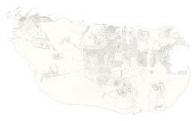
(click on the map to view full size)

The map outlines a rough route along the town’s promenade, it is purposely fragmented, pointing out details and leaving others for you to discover. Use it to explore, it will reveal anecdotes and secrets. Wander off its proposed route and discover some for yourself…

Explore the area and look out for scars from every period in Maltese history: this area is rich in pre-historic settlements and Megalithic Temples. It was the first place to be inhabited by the Phoenicians, houses the remains of a Roman Villa and is scattered with fortifications built by both the Knights of St.John and the British during WW2. More recently it has been heavily impacted by the large amount of industry thrown its way and has seen a massive influx of asylum seekers due to the proximity of the Immigration Detention Facilities. 

1. As you walk along the promenade keep an eye on the Freeport, a transshipment hub built in 1988, its large cranes cannot be missed. It is indisputably the landmark of the town, whether the inhabitants like it or not. The Freeport is quite a spectacle; dancing cranes, clumsy container liners turning in the bay, and the ‘lego-land’ repetitive patterns made by the piled up containers. It has an industrial beauty about it. Yet bear in mind that this has completely taken over every view from the town, it obscures the natural horizon, fills the bay with the echoing sound of clanking containers, and at night it floods it with yellow light. This heavy stamp of international shipping has marked Birzebbuga and its inhabitants so deeply, yet none of these containers are destined for Malta, they are stopping here in-transit. The Freeport seems a poignant reminder of much of Malta’s relationship with the rest of the world: that of being a well positioned rock - a convenient harbor, an aircraft carrier and now a concrete strip on which to leave containers.

2. On a quiet Summer’s afternoon set up your umbrella in a dilapidated hotel (accessed from the St. George’s Bay promenade). This used to be a wedding reception venue, which newlyweds would leave by boat, heading straight to Gozo for their honeymoon.

3. Swim in the shadow of the 18th century Ferretti battery.

4. Enjoy the rare moments when you can see the horizon.

5. Dream of ancient civilizations, investigate the deep wells and cart-ruts cut into the limestone seabed of St.George’s Bay. Is this where the name Birzebbuga comes from? (Bir=well, zebbuga=olive)

6. Wonder at the crazy juxtaposition of the large gas tanks towering behind pretty little houses. These were originally built by British Petroleum and are now in use by Enemalta Corporation, Malta’s main suppliers of electricity and gas.

7. In December 1989, a few weeks after the fall of the Berlin wall, Bush and Gorbachev met on a soviet cruise ship in this bay and declared the end of the cold war. Malta was chosen because of its position at the centre of the Mediterranean - where East meets West and North meets South. However the choice of location and Bush’s idea to meet on a ship was not the best of combinations, because of the bad weather – the summit became known as the ‘seasick summit’.

8. Imagine what the town used to look like. Stop and admire the ‘villeggatura’ (holiday homes) lining the seaside. Birzebbuga was once a small settlement of these pretty little two-storey houses. These ‘villaggatura’ houses once existed all over the island’s coastal towns but many have been demolished for the construction of flats or hotels. Take them in, who knows how much longer they will be here for.

9. Get political. Walk around the town's dilapidated waterpolo club. Ask a local how it ended up this way.

10. Kalafrana, where the Freeport now stands, used to be a British seaplane base, and so Birzebbuga transformed into a strip full of the bars and entertainment facilities necessary to keep the officers happy. Look around town for the Lido Cinema and other remnants of this period.

11. Buy Malta's best fish and chips from Borda's and eat them on a bench by the sea.

12. Find the perfect fishing spot.

13. Listen to the dead silence during a Bocci tournament on a Summer's evening.

14. Sit by the salt-pans and let the ground and walls reveal their stories to you. This area known as Wied il-Buni used to house two British Gun posts, a large defense wall and moat. Part of the wall is visible behind the Bocci Club and if you study the ground closely you can make out the footprints of the gun posts.

15. Drink a cisk, eat some hobz biz-zejt (preferably sitting on a metal chair) and watch the Freeport - its cranes, containers and ships.
The above is my entry in the Uncommon: Malta and Gozo, for more information check out the Uncommon Guide Book Blog:     uncommonguidebook.tumblr.com
And for a review of the book:    maltatoday.com.mt/whats_on/uncommon-malta/book-review-uncommon-malta-and-gozo
Or simply watch someone flick through the book: designyoutrust.com/2011/07/21/uncommon-guide-book-malta-gozo

Friday, March 25, 2011

"We could have been replaced by an Aircraft Carrier"


My father said this during a conversation we had over one of my maps (see more on map conversation here). This was said in relation to Malta's usefulness to the rest of the world - its strategic position at the centre of the Mediterranean. He referred to the Freeport as another example of this: a large slab of concrete on which to keep containers for transhipment, before that during WW2 it was an aircraft carrier strategically positioned between Italy and North Africa, before that a port,...

Winston Churchill called Malta the "unsinkable aircraft carrier" - perhaps this is more positive than my father's comment - since this elevates the island slightly higher than an average aircraft carrier? (Malta played a significant part in WWII and was one of the most intensively-bombed areas during the war. The German Air Force and the Italian Royal Air Force flew a total of 3,000 bombing raids over a period of two years.)

I put this image together, another play on scale, perception and identity - is this how Malta looked to its colonisers? 

Friday, April 9, 2010

In search of Maltese Architecture - A Call To Action!


Myriad underground spaces scattered all over the Maltese islands speak of a heritage in which space is not defined by enclosing it, but by painstakingly carving it out of rock. Old farmhouses reveal a multitude of inventive methods for crafting limestone to suit numerous needs. Balconies and layered front doors tell of our Arabic legacy and a complex relationship between public and private. Valletta educates on the art of city planning and Mdina on the expertly composed meander.
With such a rich and varied architectural heritage from which to learn and be inspired, and such a unique culture to express and to build spaces for, Maltese architecture could aspire to be more. Yet so little of our contemporary architecture seems comparable to that built throughout our eventful history. 
Discussions on architecture in Malta tellingly tend to follow two patterns; reminiscences on the island’s pre-building boom beauty, on our wonderful architectural heritage and the importance of conservation, or cynical rants on the contemporary, mixed with a resigned acceptance of it as an inevitable consequence of progression and a reflection of the times.

And so a conspicuous, notional divide exists between our pre-colonial and postcolonial architecture. Perhaps this is a natural symptom of a long history of colonisers applying their vision of Malta, one
on top of the other, like a layered drawing, upon our little island.

But what can we do with the metaphoric top layer? Conserve and give value to our heritage – ideally this is taken for granted. But simultaneously be inventive and ambitious, create opportunities, outside of the private sector, to develop an architectural language that has grown from this unique heritage, and is our own, and not more of the nondescript construction that exists all over the Mediterranean.

Tuesday, March 30, 2010

A Landscape inspired by Salt-Pans

Creating a landscape of platforms and pools for the public to inhabit.

The rectangular shapes and plays with volumes, edges and stepping are inspired by the salt-pans and terraced fields that make up the Maltese landscape.

Here the rectangular shapes are extruded from the landscape or cut into it, to form platforms and pools.

There will be different sized places, for different types of use. Some for hiding in, others for rising above. Some sized for whole extended families, others for individuals.


Monday, March 29, 2010

Extract from Birzebbuga Local Council Website

Below is an extract from the Birzebbuga Local Council Website. It gives a clear indication of the problems that Birzebbuga is faced with. It also gives some insight into the nostalgia and loss felt by the residents. Finally one is given an idea what the mayor's wish for the town is - although this is quite a vague, a notion rather than a proposal.


" The Mayor of Birzebbuga is Joseph Farrugia... he has lived in Birzebbuga all his life and he has seen this once small seaside village change the what it is now.

As a boy he can remember Birzebbuga as a lovely seaside village,... As time passed Birzebbuga began to be developed.

It first started with British Petroleum who built a huge fuel installation, which has become part of Enemalta Corporation. This was followed by the naval station at Kalafrana, and then the Air Force Base at Hal-Far. Since then we now have the underground fuel installation at Wied Dalam; gas tanking at Qajjanze (northern Birzebbuga); Malta International Airport 32.End runway which starts from the southeast of Birzebbuga, the Malta Freeport and, finally the Power Station.

Till now every Maltese Government we have had has tried to create even more industry and facilities on this southern side of Malta, despite the ever-increasing level of pollution levels. I do not blame any of these governments because the intention was always to create jobs. No one foresaw that we would be faced with an ever increasing level of pollution that these accidents industries, including installations have created.

The petrol tanks...are surrounded by residential homes and the fumes, which leak into the environment lead to sickness and nausea, besides the threat of living very close to a time bomb.

The flight path of Malta International Airport is directly over the town, and aircraft fly in all day and all night, with their approach being very low. This creates, not only noise pollution, for the whole town, but the residents living in the flight path suffer from lack of sleep and continual disturbance.

The Freeport was built to encourage trade and industry. It created jobs and gives security to many people. Once again, it was built in a residential area, albeit opposite has created the coastline. In fact, the site used was the Kalafrana naval station. The pollution this has created is excessive noise at night with total disregard for the residents, especially when containers are either dropped or banged together; the generators, which are used for power, and sea pollution, again regardless of the fact that Birzebbuga is a seaside resort with its own hotel.

The Power Station was built to provide electricity to the southern part of Malta. The pollution this creates is one of black dust emissions, which fills the air and covers the houses with black dust.

Many of the residents, especially the children, suffer from asthma and bronchial related illnesses because of the excessive air pollution. They also suffer from lack of concentration at school due to being distributed at night by both air craft and Freeport.

Today, Birzebbuga has endured a great deal of damage to its way of life. Mr. Farrugia that it is not enough to compensate the residents by building of a new road, which will not benefit anyone, or planting trees which will have no effect on their lives. Drastic action is needed to be taken to solve this problem of pollution in order to give the residents a better quality of life and a cleaner environment for the benefit of the children.

It is the Mayor’s wish that the people of Birzebbuga who have lost entirely the clean environment, which the old folk used to enjoy, will be compensated in such a way that benefits them for the rest of their lives. The Mayor, and his fellow Councillors acknowledge very seriously that what Birzebbuga has lost can never be regained, but they can save what has not been lost and which is still good. "

taken from: http://www.birzebbugalc.com/History_1.html

Tuesday, January 26, 2010

A Memory Map of Malta

Whilst in London, I drew a map of Malta from memory. It was a way of capturing all my idealistic images of home from overseas. These would be erased on my return, by immersion into research and by the reality I would be faced with (which often is a sharper but less beautiful version of a memory). The map is distorted by nostalgia (homesickness), it is completely inaccurate.

(click on the image to enlarge)

As I drew it I began to feel quite uncomfortable. I started to realize that it reveals more about me than about Malta, and the thought of ever showing it to a Maltese person made me uncomfortable, for they would be able to read all sorts of things about me by looking at the map. The map shows the areas of the island that I know well, and hold dear revealing my social class, first language, clues to my family history, interests,...

Since this map is my version of Malta - and since I don't want the project to be completely from my perspective - I decided to get the map corrected, so that it slowly became the Maltese* version of Malta. I made 10 copies of the map and went home equipped with a tape recorder, red marker pens and a lot of time and patience. I would ask as many people as possible to draw their version of the map over mine.

keep reading the blog to know what happened next...


*I say "Maltese" for lack of a better word. I wish to use a word that does not in any way exclude people who live in Malta, or consider Malta their home, but are not defined as "Maltese". However I chose to use "Maltese" because it contrasts with previous versions of Malta that were presented by colonisers, because I hope to give value to the "Maltese" perspective by mapping it.

Monday, December 7, 2009

Introduction to Malta

Image of the Maltese Archipelago as it appears on a world map - the star that marks the capital city almost covers the whole island.


Capital: Valletta
Area: 316 km2
Population: 413,609
Population Density: 1,298/km2 (6th)
Sicily: 93km North
Tunisia: 288km West
Religion: 98% Roman Catholic
Independence from the UK: 21 September 1964
EU Accession: 1 May 2004
Official Languages: Maltese, English
Ethnic Groups: Maltese 95.3%, British 1.6%, other 3.1%


Malta is a tiny island of seemingly insignificant size, unknown to most of the world, yet it was once fought over because of its strategic position at the centre of the Mediterranean. This resulted in its being colonised by numerous empires: Carthaginians, Romans, Arabs, Normans, Sicilians, Knights of St.John, French and British, each leaving its own mark on the islands and their people.

‘Sunny Malta’ is mostly known as a cheap, English-speaking package-holiday destination yet less known is that it is the 6th most densely populated country in the world and home to the world’s oldest freestanding structures.

Ninety-eight percent of the population is Roman Catholic (thanks to St.Paul for famously being shipwrecked on the island), making the nation one of the most Catholic countries in the world, yet they praise ‘Alla’ meaning God in Maltese - which is an Arabic dialect, the only official language of the EU that is defined as semitic and the only semitic language that is written in the latin alphabet. Maltese and English were recognised as official languages when they replaced Italian in 1934, making for a bilingual country in which 86% of the population prefer to speak Maltese, 12% English, and 2% Italian.